Click on pictures to enlarge them.
|
|
|
New South Wales
|
|
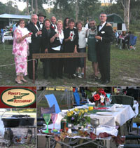
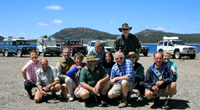
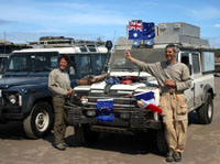
How about a black tie dinner in the bush of New South Wales? Among the other guests of the 2007 Rover's Bush Restaurant were our fellow 4x4 travellers from the Tasmania trip two months earlier. A happy reunion indeed!
|
|
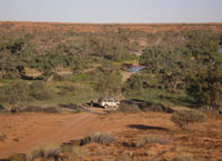
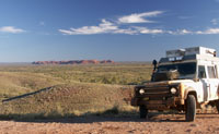
At the western end of New South Wales, Cameron's Corner marks the border between both states of South Australia and Queensland. Recent torrential rains have turned the clay into mud, thus giving us a chance to stretch and sweat a bit. It took the flies only a few minutes to spot us, but we were ready for them, with our new airy fly nets. Thanks to the thoughtful lady who shared this Aussie secret with us!
|
|
|
|
Corner Country
|
|
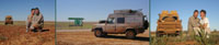
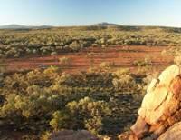
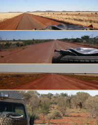
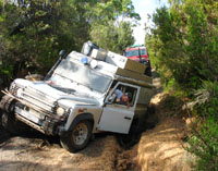
Corner Country, Australia. Alistair retained its recent "war paint" for several days on the tracks, while driving through Innamincka and the Sturt Stony Desert. We are well on our way to Birdsville -- 600 km north of Cameron's Corner -- and the Simpson Desert gates are now only a hundred kilometers away.
|
|
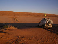
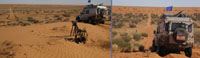
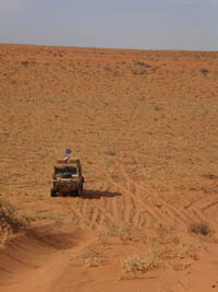
The Simpson Desert: 1240 km of parallel sand dunes which we will cross from east to west, in the opposite direction from the main winds. This means that we will be climbing those sand dunes on the steeper side. Flying a flag is highly recommended in order to be more visible and avoid encountering vehicles from the opposite direction right upon reaching a dune crest.
|
|
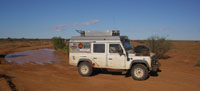
During our first hour of driving in the Simpson Desert, we crossed two creeks. Since the rains stopped a few days ago, they have shrunk into a couple of large pools. Once past these holes, the next water source is Purni Bore, 300 km away and three full days of driving in the sand.
|
|
A thought for the pilot of this motorbike, just a skeleton being slowly sanded by the winds of the Simpson Desert.
|
|
Poepple's Corner, a border point between Queensland, South Australia and the Northern Territory, is right behind us. Beyond this saltpan stretch appears the first dune of the French Line. This track was opened in the early 60's by an exploration team from a French oil company.
|
|
|
|
Northern Territory
|
|
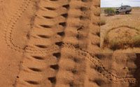
Northern Territory, Australia. In the morning, we discover that little tracks crossed our own during the night... while it took years for these strange circles to be drawn in the sand by a plant associated with a fungus.
|
|
When ascending a sand dune with a heavily loaded vehicle such as ours, keeping momentum is critical. That's when choosing the right path is key to getting across on first attempt. The most frustrating scenario we encountered in the Simpson Desert was when, at the base of the dune, suddenly appeared in front of us 5 to 10 meters of corrugations which made us lose momentum...
|
|
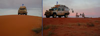
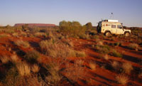
As the daylight declines, the sand gradually turns from orange to dark red. The crest of a tall sand dune makes a breezy camp spot for a good night's sleep. It makes a difference when the next day starts early well before sunrise, when the sand is still cold and firm. The dunes ahead of us are the tallest and steepest of the Simpson... that is apart from the so called "Big Red" outside Birdsville.
|
|
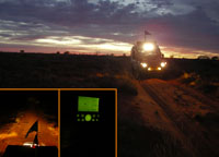
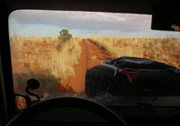
In the darkness, corrugations are easy to spot under our headlight beams. But as the sun rises in our backs, they become less and less visible.
|
|
Gradually, the sand colour turns from red to orange. If all goes well, this third day on sand tracks should also be our last in the Simpson Desert.
|
|
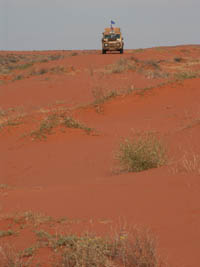
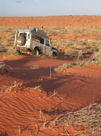
The Simpson Desert is a long string of sand dunes. Vegetation is scarce on their crests, while the valleys stretching between series of dunes are covered with bushes.
|
|
Small bushes have now been replaced by patches of yellow spinifex combined with an occasional small tree or large shrub: these are clear signs that the other end of the Simpson Desert is near.
|
|
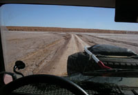
We have barely left behind the sand of the Simpson that we slip and slide on muddy tracks again. A couple of hours later, we reach Kulgera and return on tarmac at last. We had left bitumen in Wilcannia, and clocked 1989 km in a row on tracks, the only possible land alternative through Corner Country -- that is apart from 2 km of bitumen near Birdsville which serve as an emergency air strip.
|
|
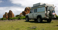
We chose not to rush on our way to Uluru and take the time to explore first a rock formation of lesser fame. Mount Conner is no less impressive yet much quieter.
|
|
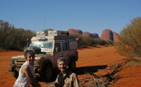
In order to enjoy the Olgas-Kata Tjuta away from the noisy crowds of tourists, we took the first portion of this track which further on crosses the Gibson Desert and leads to Western Australia.
|
|
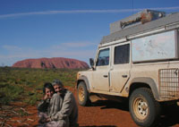
Ayers Rock-Uluru, an icon of Australian "Red Centre" is encircled by a bitumen road which provides easy access for hundreds of buses and thousands of tourists on a tight schedule.
|
|
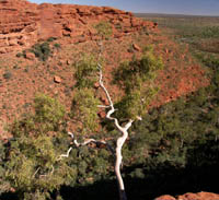
At Kings Canyon, another touristy stop on our way, Alistair had to wait for us on the parking lot while we continued on foot.
|
|
The track crossing the Finke River National Park from south to north led us to this beautifully remote camp spot. During our entire weekend there, we only passed three vehicles in the northern portion of the park. And to think that June is the perfect time of year to camp in the area...
|
|
Located north of Gosse Bluff -- or Tnolara in the local Aboriginal language -- Tyler Pass offers a breathtaking view of this gigantic crater -- 8 km in diameter, 200 meters high -- which was created by a collision with a comet.
|
|
Bush camping in the West Mac Donnell Ranges with a view in the distance of Mounts Zeil and Razorback.
|
|
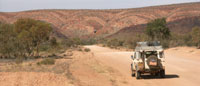
This track which runs parallel to the West Mac Donnell Ranges takes the amateur geologist to Alice Springs through a detour of pure delight.
|
|
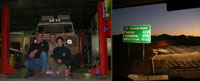
Northern Territory, Australia. In Alice Springs, Alistair was treated to an oil change and a thorough checkup by an expert, "Bigjon". A healthy measure before hitting the Tanami Track on our way to Halls Creek and Western Australia.
|
|
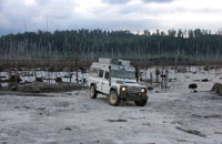
Northern Territory, Australia. The Tanami Road begins as a one-lane stretch of bitumen cutting through a carpet of yellow spinifex. Two hundred kilometers further on, the landscape has turned into scarce vegetation of low bushes and a dirt track. Alistair's windscreen could testify that there is some gravel too. Luckily, we did not encounter any animal!
|
|
|
|
Tasmania
|
|
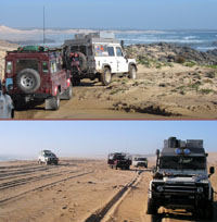
Australia, in north-east Tasmania. A sandy track leads to Waterhouse Point. Further in the background, Cape Portland, is another 4WD only destination.
|
|
Australia, Tasmania. Joining a fine team from New South Wales to discover Tasmania together with our 4WDs. Giving us the opportunity to tag along for 3 weeks was a great experience, complete with authentic Australian "bush camping" and wonderful new friends.
|
|
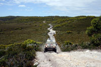
Australia, Tasmania. 25 kilometers of beach driving ahead of us to reach Sandy Cape, on the north-west of the island. The first cove, Hazard Bay, derives its name from the quicksands which appear after the rain, when water starts its course on the moor and ends up under the sand. On average, one vehicle per year is sunk and lost forever! As a general rule, quicksands tend to be of a slightly darker shade, due to tannins oozing out of vegetation. In case of need to act quickly, we had recovery straps already tied to the car recovery point and secured with bungee on the spare wheel.
|
|
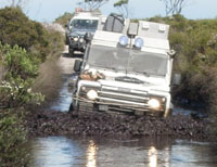
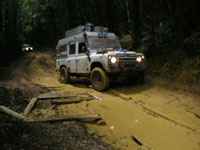
Australia, Tasmania. A good start on the Balfour Track. In the deepest bog-holes, water came up only above our headlights. And the bottom of it is all rocks...
|
|
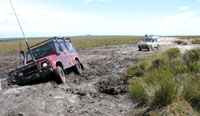
Australia, Tasmania. In the vicinity of the Balfour track, one can easily be caught unawares. Recovery straps had not been needed in the sand but were here put to good use in the mud after all!
|
|
Australia, Tasmania. The black marks not yet dried on Alistair's sides come from the bog-holes on the Balfour track. This photo is a fun souvenir of the westernmost track we took in Tasmania.
|
|
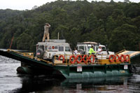
Australia, Tasmania. On the west coast of Tasmania, crossing the Pieman River with the cable-operated ferry. Alistair's roof is always a good observation platform!
|
|
Australia, Tasmania. On the tracks of Pieman River State Reserve, north of Granville Harbour to find the mythical spot of "Conical Rocks".
|
|
Australia, Tasmania. "Conical Rocks" giant boulders have been polished by the rain and winds coming from Antarctica while at their feet, rough waters would make for a quite dangerous approach by sea. To reach this place you need a 4WD... or a helicopter!
|
|
Australia, Tasmania. Built through the mountains by some forgotten mining company, this railroad track is now just a narrow, muddy trail through a temperate rain forest. It leads to "Montezuma Falls", which share their name with the local mine and are one of the highest in Tasmania.
|
|
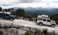
Australia, Tasmania. High above Lake Burbury, under fantastic Tasmanian skies, heading towards the very remote Bird River.
|
|
Australia, Tasmania. North of Lake Pedder, the track beyond the ghost gold-mines of Adamsfield is quite broken up!
|
|
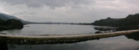
Australia, Tasmania. On the shores of Lake Pedder. Severe variations in water levels affected by the dam and current droughts and combined with forest fires have created this desolate landscape which looks even gloomier under stormy skies.
|
|
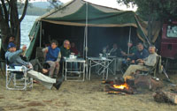
Australia, Tasmania. Roger, our group leader often says that "the secret to a fun camping experience is good water, good fire, good company, yet the two first ones are optional". At Bronte Lagoon, we had good water and wood... on top of the essential.
|
|
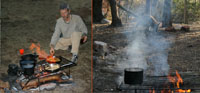
Australia, Tasmania. We learned a few good tricks about bush cooking on wood-fire with traditional Australian camp ovens. To reciprocate, we cooked for dessert some French crêpes for our friends: thin pancakes stuffed with sliced and caramelized apples flambéed with cognac. An unexpected visitor was watching too! Utensils and cookware were borrowed from Roger who organises a yearly black-tie dinner in the bush, called Rover's Bush Restaurant !
|
|
Australia, Tasmania. Between Lake Gordon and Lake Pedder, one last "family photo" before splitting from the group.
|
|
|
|
South Australia
|
|
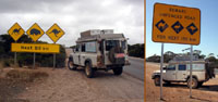
South Australia. The Nullarbor plain stretching for 1200 km between the states of Western and South Australia, is lined with road signs which are quite exotic for a European visitor: camel, emu, wombat and of course, kangaroo!
|
|
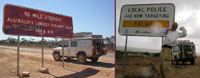
South Australia. During the 1200 km-long Nullarbor Plain crossing, the longest straight line stretches for 146 kilomètres! You said "Nullarboring"?
|
|
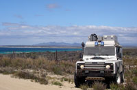
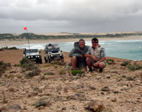
South Australia. A fine outing on the coast south of Mount Gambier for which we had the pleasure of being guided by Ruslan in his Defender.
|
|
|